Public learning - Harnessing the power of exhibitions for transformative change
Public learning - Harnessing the power of exhibitions for transformative change
What happens when ordinary citizens are confronted with images that are either deeply familiar or unfamiliar to their everyday life and experience of urban risk? When and how does such learning of the city have the potential to trigger transformative change? Adriana Allen, the Bartlett Development Planning Unit at University College, London, reports from Lima, Peru.
This article continues from a previous exploration of how ordinary citizens learn about urban risk. It reflects on the potential of public exhibitions to address stigma and exclusion by reframing popular perceptions of who lives at risk, where and why.
By ‘public learning’, we mean the relational process by which ordinary citizens make sense of cities collectively. This process has the capacity to make the invisible visible and to raise public awareness. It also has potential to foster spaces for collective dialogue and advocacy, to trigger imaginings of how the city could be more just and resilient, and to set precedents for transformative action and to consolidate institutional commitment towards that aim.
The discussion examines the tangible and intangible outcomes of a travelling public exhibition that shares the process and outcomes of the work undertaken by cLIMA sin Riesgo, an action-research project supported by CDKN that focuses on Lima, Peru.
In Lima, like in many other cities, the mapping of risk is based on technical and scientific studies focused on the assessment of urban resilience and/or fragility in the face of intensive disasters caused by natural events of short duration and high impact, such as earthquakes. Although this approach offers valuable information, it does not make visible the accumulation of extensive or small scale risks, and the resultant reproduction of urban risk traps exacerbated by climate change effects and recurring climatic events like El Niño. cLIMA sin Riesgo seeks to develop spatial knowledge on urban risk, evaluate the present investments made and actions taken to mitigate risks, and produce robust evidence to support new strategies for climate-resilient and just urban development. Surveying and mapping vulnerabilities and physical risk conditions forms an important part of this work.
Bringing invisible risks to the public eye
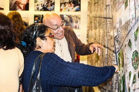
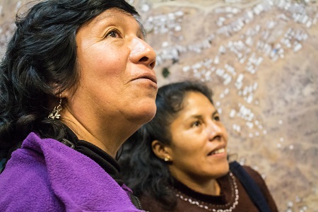
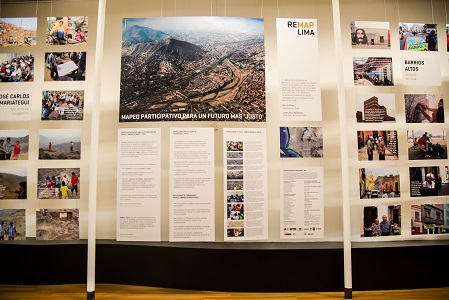
The process and outcomes of the cLIMA sin Riesgo mapping / surveying process was documented through a public exhibition launched in November 2015 in association with  UNESCO and the Ministry of Culture, Peru. Since then, the exhibition has travelled through different public sites in the city and attracted more than 3,000 visitors and wide media attention. In addition, several delegations from organisations in Germany and the United States, among other countries, have learnt what risk means in Lima at the local scale and on an everyday basis, beyond the familiar theme of the large-scale emergency.
The travelling exhibition brings a reality that is often ignored to the attention of members of the public and institutions. This raises awareness about the everyday risks faced by women and men in the centre and periphery of the city. It also helps to challenge homogenising assumptions that stigmatise those living in risk in these areas as either criminals or land traffickers who profit from the illegal acquisition and sale of property.
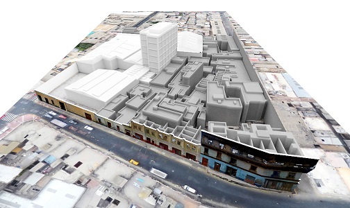
Lima's Barrios Altos is often portrayed as a dangerous neighbourhood and a site of criminal activity. José Carlos Mariátegui, on the other hand, is recurrently described as an area expanding solely due to the unlawful actions of those involved in land grabbing and trafficking.
By contrast, the exhibition brings to the public eye a fresh framing of both areas. Through cartography, story maps and testimonies from the female and male residents involved in the process of mapping their own neighbourhoods, it captures the reality faced by impoverished and decent tenants living behind the facades of the historic buildings in Barrios Altos or forced to occupy the steep slopes in José Carlos Mariátegui, driven by the unmet demand for affordable housing and land elsewhere in the city.
This enables visitors to develop a deeper spatial understanding of the everyday risks that affect the present and future quality of life of those living in conditions of poverty and vulnerability. Furthermore, the images help the public to appreciate that local dwellers are not powerless and passive victims but women and men with the capacity to act, who - even if often ignored - actively seek to make Lima an inclusive and resilient city by adopting individual and collective practices to improve their dwellings, common spaces and access to basic services and to minimise the impacts that different hazards such as fires, rockslides, buildings collapse and gastrointestinal diseases impose upon their lives on a daily or episodic basis.
Expanding the scope for transformation
In turn, a fresh perspective on risk, jointly constructed with local dwellers in the centre and periphery of the city, opened new spaces for dialogue and advocacy. The scope for transformative actions to disrupt vicious risk accumulation cycles or 'urban risk traps' has been expanded by the establishment of the Observatory for the Historic Centre of Lima, a collaboration with cLIMA sin Riesgo endorsed by UNESCO and the Ministry of Culture, Peru. The observatory is a platform for monitoring risk and expanding citizen and stakeholder participation in order to recover a living and inclusive city centre, in which social and environmental justice are preserved and promoted together with the residentiality and historic value of the city centre.
A similar observatory is being established in the periphery of the city in collaboration with the district municipality of San Juan de Lurigancho. Both initiatives are championed by the local organisations participating in this project, CIDAP, CENCA and Foro Ciudades para la Vida, organisations that are collaborators in the project and have a long-standing record of working towards climate-resilient and just urbanisation in Lima.
Harnessing the power of public exhibitions
Thanks to the public exposure the process has received through the exhibition, the National Centre of Appraisal, Prevention and Reduction of Disaster Risks (CENEPRED) and the Ministry of Environment (MINAM) have expressed interest in supplementing their own methodologies with the mapping / surveying methodology developed by cLIMA sin Riesgo to assess vulnerabilities and physical risk conditions.
The emergency declaration in response to El Niño Southern Oscillation (ENSO) has triggered the redeployment of a large amount of resources to respond to potential emergency conditions, but without consistent planning. Planning in general, and climate-resilient planning in particular, is a challenging aspect in Peru at metropolitan and national level. Although a Climate Change Adaptation and Mitigation Strategy was approved during the previous municipal administration, it is still unclear whether it will be implemented, and how. Climate-resilient planning is even more challenging considering the historical focus on large-scale disasters and the bias toward emergencies. In this context, the institutional commitment achieved and cemented through the public learning process described above represents an essential step towards the adoption of strategic actions.
Imagining possible urban futures
In the forthcoming months, cLIMA sin Riesgo will include the application of scenario risk planning and the development of innovative funding mechanisms. The latter will be facilitated through the local observatories established by the project in collaboration with key institutions, and will support the co-financing of pilot actions to mitigate, reduce and prevent everyday risks. These actions will be documented and used to produce another forward-loop in public and institutional learning that will set valuable precedents and hopefully trigger further initiatives towards the disruption of urban risk traps in Lima and elsewhere.
To learn more about the project or to expand the ongoing learning process to other cities, please register on the bilingual website of the project at www.climasinriesgonet and/or contact:
Prof. Adriana Allen, a.allen@ucl.ac.uk
cLIMAsin Riesgo, Principal Investigator
The Bartlett Development Planning Unit (DPU), University College London


