Earth Observation data
Earth Observation data
Earth Observation data can fill gaps in field monitoring and measuring in data-scarce regions, and so improve our understanding of climate change - says Georgina Wade of Acclimatise. Urban planners in Monrovia, Liberia are already benefitting from this approach.
Climate change is among the top societal challenges with global impact. It has wide-ranging impacts across socio-economic systems, with the most severe effects being faced by poor and vulnerable communities. Making climate-resilient decisions requires good quality data and information, often lacking in many developing regions of the world. Earth observation (EO) data has the capability to capture large-scale environmental data over a range of spatial, spectral and temporal resolutions. Some governments have started accessing EO data to incorporate adaptation options into their planning and improve the climate resilience of livelihoods and production systems. For instance, since 2005, India has launched 17 EO satellites into space to gather invaluable information on different climate variables to improve resource management and disseminate timely disaster warnings.
Building resilience in regions where data is scarce
EO is the gathering of information about the Earth’s physical, chemical and biological systems and has the capability to do so across remote and inaccessible terrain. It involves monitoring and assessing the status of and changes in the natural and man-made environment. EO data provide large quantities of timely and accurate environmental information, which, when combined with socioeconomic data can give unique insights into managing climate risks. This is especially important in regions where insufficient information is available from in-situ measurements, or where on-the-ground assessments of infrastructure are not possible due to safety concerns. EO satellites can collect real time data on a wide range of indicators such as water distribution, land use, water cycles, atmospheric profiles, heat mapping, sea surface evaluations, and global-regional energy exchanges.
EO data can help governments around the world not only prepare for climate change impacts and natural disasters, but also inform sustainable and climate resilient development planning to account for future climate risks.
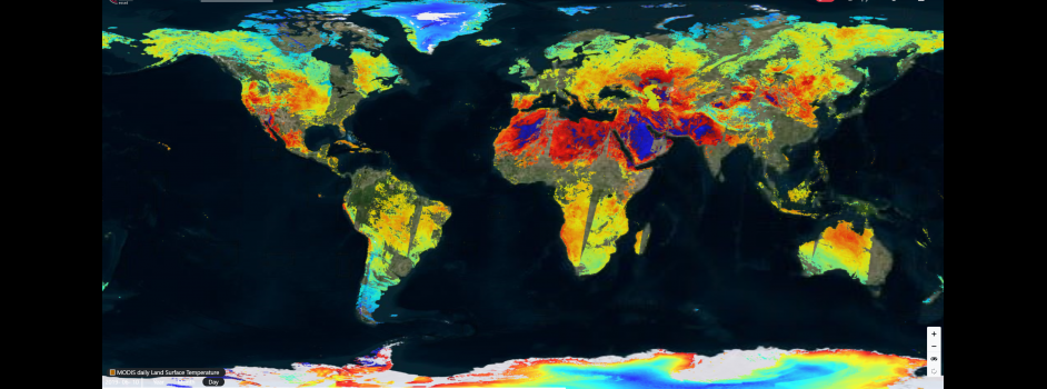
Image: MODIS daily land surface temperature
The Earth Observation for Sustainable Development (EO4SD) Climate Resilience Cluster, an initiative by the European Space Agency (ESA), combines EO-based environmental information with socioeconomic and climate data in developing countries to help them meet long-term climate resilient development planning goals.
Monrovia, Liberia: Earth Observation data reveals coastal vulnerability
One example of the Cluster’s work is in Monrovia, Liberia, in collaboration with World Bank’s Greater Monrovia Urban Review project, which aims identify policies that can help Monrovia be better prepared to absorb urban growth in a context of extreme poverty/informality, fragility and increasing risks from climate change.
Monrovia is at extremely high risk of coastal and inland flooding, which has already displaced poor communities living along the coastline and will only worsen with climate change. The Cluster has developed EO product prototypes that model coastal and inland risk flooding due to sea level rise and coastal erosion in Monrovia.
With Liberia continuing to urbanise at pace, climate change is projected to aggravate existing developmental challenges, slowing down economic growth through reduced productivity from climate-sensitive sectors and damage to critical infrastructure. Climate change also poses critical threats to Liberia’s public health, the agriculture sector, and its coastal zone where much of the population and assets are concentrated.
Liberia’s capital city, Monrovia, has all the characteristics of a fragile city. A majority of the population in Greater Monrovia lives in slums, with some being subject to frequent flooding, a problem that will be exacerbated by climate change. Electricity and piped water are scarce and are typically found in houses belonging to the upper class. Additionally, Greater Monrovia’s road capacity and education systems lag far behind those of other cities.
The World Bank’s MIDP aims to identify adaptation policies that can help Monrovia be better prepared to absorb urban growth in a context of extreme poverty, fragility and increasing risks from climate change. Several adaptation solutions were offered up by the EO4SD climate cluster, but two activities were ultimately chosen to compliment the World Bank’s Great Monrovia Urban Review project.
1) Soil erosion service
Since 2013, sea level rise and coastal erosion has displaced more than 6,500 and destroyed 800 houses in the West Point township of Monrovia. Sea level rise leads to erosion and causes the shoreline to retreat landwards, increasing the risk of displacement. Dwellings built in 2010, favoured by land gains due to the shoreline and river dynamics, are at a high risk of flooding. In response, the cluster undertook shoreline monitoring and change detection in Greater Monrovia. The soil erosion service based on EO data helps the World Bank determine where to best make investments and identify hotspot areas that need immediate attention.
2) Flood Risk Service
The second EO based service involves hot spot analysis of flood modelling in Monrovia, showing the potential coastal and inland flooding for the city in the year 2030. Using high-resolution sea-level rise data obtained from shoreline change in Monrovia’s metropolitan area from 1985 to 2019, the sea level rise estimation is used to identify coastal and inland flood risk areas. The potential of these flood events is then combined with population exposure to estimate the flood risk to the general population.
The flood risk analysis could also be enhanced, in future, with the inclusion of critical infrastructure analyses, hydrological information, and projections of coastal erosion and land subsidence. These flood maps can help authorities to identify the most effective actions to manage flood risk, develop adaptation plans, consider where natural flood management could be most effective, and enable better planning decisions to avoid unnecessary development in flood risk areas. This illustrates how EO can support the implementation of climate adaptation solutions for regions affected by sea level rise and flooding.
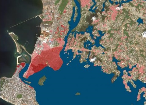
Hotspot analysis of flood risk intersected with population density for Clara Town (Greater Monrovia). Risk severity depicted by red gradient colours
Next steps and potential for further application
The two prototype services described above were delivered within the first phase of the EO4SD climate resilience cluster project, ending July 2019. In the second phase of the project, which runs until June 2021, further EO-based services will be provided, including integration of climate projections and socioeconomic data in the flood risk analysis, to better identify climate risks, and an estimation of projected coastal erosion up to 2030. New products and services can also be provided for different hazards or locations. With the World Bank’s MIDP project currently in its planning stages, these EO-based services help lay the groundwork for the World Bank team and city stakeholders in identifying key climate-resilient interventions for the city of Monrovia, to be implemented over the coming years.
In Phase 2, new products will be developed and the prototypes further elaborated by integrating other datasets, for example, the flood risk analysis can integrate critical infrastructure data, hydrologic information, projections for coastal erosion and land subsidence. Employing a mix of EO, climate projections and socioeconomic data will help integrate climate resilience into investments under the Greater Monrovia projects.