Climate information to help combat malaria in Ethiopia
Climate information to help combat malaria in Ethiopia
An initiative called ENACTS has made climate information easier for Ethiopian health professionals to access and use. This has helped them to pinpoint which districts will be most exposed to the climatic conditions that foster the spread of malaria – and to better target malaria control measures.
Ethiopia has a varied landscape, which gives rise to a diverse climate. Its central plateau ranges from 1,290 to 3,000 metres high and covers two-thirds of the country’s land area. By contrast, hot, humid lowlands cover part of western Ethiopia and the southeast of the country is characterised by hot, dry plains. As a result of this topography, one can travel rapidly from one climate extreme to another in a short distance[1].
Malaria is a scourge across 75% of the country. More than 50 million people are at risk of malaria and this life-threatening disease affects four to five million people in Ethiopia every year.
Malaria is not a year-round phenomenon in Ethiopia, however. There are two rainy seasons per year; malaria transmission follows each rainy season and continues for a month or more after it ends, as long as temperatures are suitable.
Temperature influences the development rate and survival of malaria parasites and of the mosquitos that spread malaria while rainfall helps create mosquito breeding sites and increases humidity (which in turn supports survival of adult mosquitoes).[2]
Climate variability has been shown to have a critical role in the occurrence of malaria outbreaks in Ethiopia’s highlands. Higher-than-normal rates of malaria in Ethiopia have been associated with higher temperatures in the current and preceding season, often associated with El Nino.[3] Evidence suggests that warming temperatures are putting new human populations at risk of the disease, at higher altitudes.[4]
Making climate information available at district level
Enhancing National Climate Services (ENACTS)[5] is an initiative to “create a user-focused climate service that targets national and subnational decision-makers.”[6] ENACTS is undertaken by National Meteorological and Hydrological Services and Regional Climate Centres in Africa with the support of the International Research Institute for Climate and Society and other partners.
ENACTS’ flagship activity is the creation of online ‘maprooms’, which present weather and climate information in user-friendly ways (see http://iridl.ldeo.columbia.edu/maproom/index.html).
ENACTS is a multi-donor initiative, whose work has been funded in Ethiopia by the Google Foundation[7], USAID’s President’s Malaria Initiative, the US National Institute for Health, the UK’s Department for International Development (DFID) and others. Since 2016, the Weather and Climate Information Services for Africa (WISER) programme – supported by DFID – has provided complementary funding, to foster ENACTS implementation in Ethiopia and other African countries.
In Ethiopia, the ENACTS team has made meteorological information more relevant and accessible to a wide range of decision-makers at district level; and has also targeted information specifically to health professionals.
The ENACTS data for Ethiopia provides more than 34 years of rainfall data and more than 50 years of temperature data. It combines both ground station, elevation, satellite and re-analysis data.[8]
The ENACTS team used the data to produce district-level ‘climate guides’, with eight prepared during the period of WISER support.[9] For the district or ‘woreda’ level in Ethiopia, the guides provide:
- Climate and agro-climatic guidance;
- Information about when the ‘Kiremt’ main rainy season from June to September starts and stops. This not only helps farmers to know when to plant and harvest crops and move livestock; the information is also of critical importance to the health sector.
Guidance for health professionals
Although the incidence and spread of malaria in Ethiopia is influenced by temperature and rainfall, Ethiopian health department officials previously found it difficult to access meteorological data, which could guide malaria control measures. Specifically, if they had more accurate information about the high risk periods for malaria transmission, that would lead to better-targeted public health interventions.
One of the ENACTS project’s major achievements has been to create an online maproom that depicts when conditions are ripe for malaria to occur and spread, according to district and time of year. (This builds on existing maprooms, the project developed for Ethiopia, which visualise climate and environment information at the click of a mouse.)
This online tool maps data on rainfall and temperature (with the addition of a humidity climatology): showing when climate thresholds are reached to support the transmission of malaria and therefore put the human population at risk. The tool can be used to:
- Estimate the probable length of the main malaria season(s);
- Plan for the timing of control activities, including dissemination of malaria commodities to individual districts;
- Identify epidemic-prone districts;
- Identify districts where increasing temperature or precipitation trends may increase malaria transmission.[10]
It cannot, however, be used to predict epidemics in the coming season/year or to investigate malaria risk caused by factors other than rainfall, humidity and temperature.
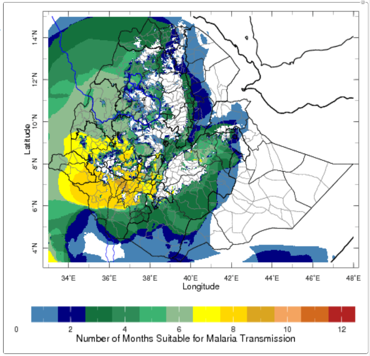
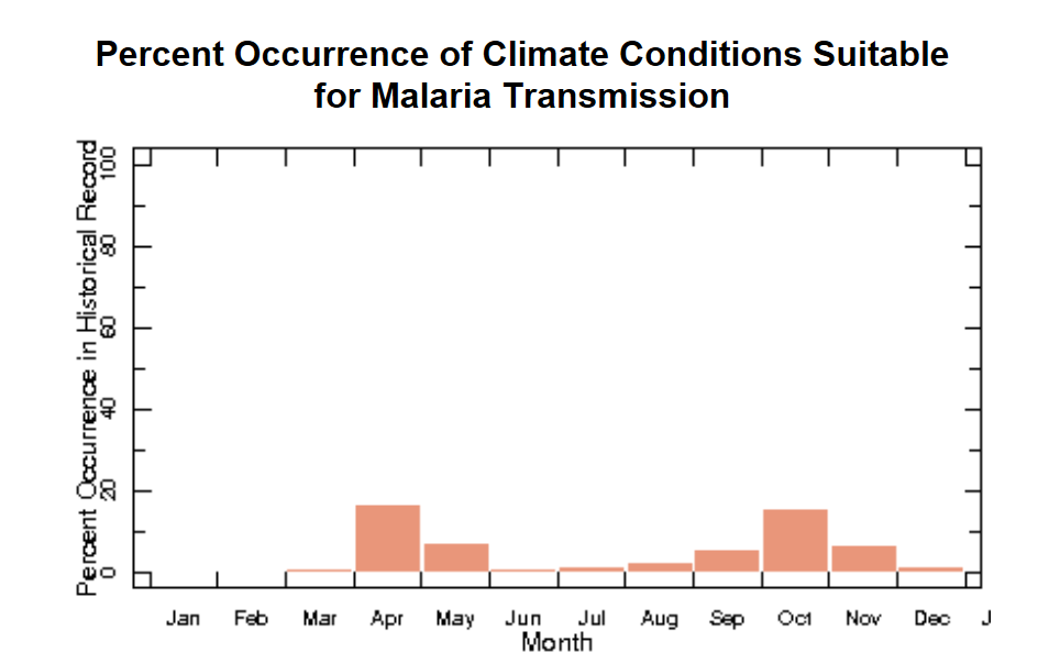
This map shows the number of months suitable for malaria transmission, based on climatological averages. Conditions are suitable for malaria when rainfall accumulation is greater than 80 mm, mean temperature is between 18°C and 32°C, and relative humidity is greater than 60%. All of these factors influence mosquito development as well as development of the Plasmodium [malaria] parasite itself within the mosquito vectors – see maproom.
Users can use filters in the maproom to zoom in on a particular area – in this case, the Somali region of Ethiopia – to discover when malaria transmission is likely to occur there.
Awareness-raising and training to empower students and health workers
In 2016, the ENACTS team presented analyses of the relationship between climate variability and malaria and other climate-sensitive diseases to Ethiopian health professionals. This included scrutinising the impact of the El Niño Southern Oscillation on malaria - because year-to-year variability in rainfall and temperature is partly associated with El Niño. The purpose was to improve climate-sensitive policy and practice in the health sector.
Subsequently, Ethiopia’s National Meteorological Agency, the Department of Health and other ENACTS partners developed training for health workers and university students on ‘Climatic Suitability for Malaria Transmission’ in Ethiopia, using the online maproom tool. The partners also committed to briefing the media on the role of climate and weather as one of several factors in fostering the conditions for malaria’s occurrence and spread. The partners also agreed to mention climate information as part of routine health bulletins.
Most recently (October 2018), a training led by Ethiopia’s National Meteorological Agency guided their own agency staff plus sectoral workers from health, agriculture and disasters departments on use of the maproom. Dr Adugna Woyessa, from the Ethiopian Public Health Institute, led outreach on the maproom tool at the Ethiopian Public Health Association national conference last month (March 2019). “We need more people to be trained so they can use the maprooms,” he said.
Linking district and national activities to a regional centre of excellence
In all of this, a pivotal aspect of WISER support has been to link these district and national activities in Ethiopia with a regional centre of excellence. Dr Madeleine Thomson, who directs a World Health Organization Collaborating Center on Climate Sensitive Diseases at Columbia University, said:
“WISER support has been critical in building the capacity of the IGAD Climate Prediction and Applications Centre (ICPAC) as a regional centre that can support the ENACTS implementing countries.”
“WISER is making substantial investments in ICPAC’s computing and IT facilities to allow it to better produce forecasts to meet their user’s needs, and as a regional resource that can be accessed by ICPAC member states such as Ethiopia (for a full list of ICPAC member states, click here).
“Ultimately, we aim to enhance the resilience of poor people and of economic development to weather and climate related shocks. ICPAC is increasing its capacity to deliver wide-reaching, usable, new, improved weather and climate products and services that are anchored in principles of co-production and user engagement. It’s becoming a knowledge and learning hub on which governments such as Ethiopia’s can rely for best practice and technical guidance.”
This impact story was written by Mairi Dupar, ODI of the WISER TRANSFORM team, with thanks to Madeleine Thomson of Columbia University for extensive inputs.
Image: malaria net distribution, courtesy Andrew Heavens, flickr.
References
[1] Topographical description from Owusu, A., M. Thomson, and A. Woyessa (forthcoming, 2019). ‘NMA ENACTS: An example of a co-produced climate service’ in WISER co-production manual.
[2] Zhou, G., M. Noboru, A. Githeko and G. Yan (2004). ‘Association between climate variability and malaria epidemics in the East African highlands.’ Proc Natl Acad Sci U S A. 2004 Feb 24; 101(8): 2375–2380.
[3] Siraj, A. S., M. Santos-Vega, M. Bouma, D. Yadeta, D. Ruiz Carrascal and M. Pascual (2014). "Altitudinal Changes in Malaria Incidence in Highlands of Ethiopia and Colombia." Science 343(6175): 1154-1158. 10.1126/science.1244325
[4] Lyon, B., Dinku, T., Raman, A., Thomson, M.C. (2017) “Temperature Suitability for Malaria Climbing the Ethiopian Highlands" Environmental Research Letters 12, 6, 064015 DOI: 10.1088/1748-9326/aa64e6)
[5] https://iri.columbia.edu/resources/enacts/
[6] Owusu, A., Thomson, M. and Woyessa, A. (forthcoming, 2019). ‘NMA ENACTS: An example of a co-produced climate service’ in WISER co-production manual.
[7] Connor, S. J., M. C. Thomson and S. M. Mason (2011). “Final report on Activities of the IRI-Google.org project: Building capacity to produce and use climate and environmental information for improving health in East Africa.” New York.
[8] Hailemariam, Kinfe (November 2017). WISER-ENACTS Second Showcase Workshop. Nairobi, Kenya (source: https://drive.google.com/file/d/1ROgM74FAlNIkPQbXk-X77GXG4ys0H_Pb/view).
[9] Ibid.
[10] ENACTS (2016). Climatic Suitability for Malaria Transmission (CSMT) Training – Ethiopia, v.1. https://iri.columbia.edu/wp-content/uploads/2016/05/csmt_nma.pdf